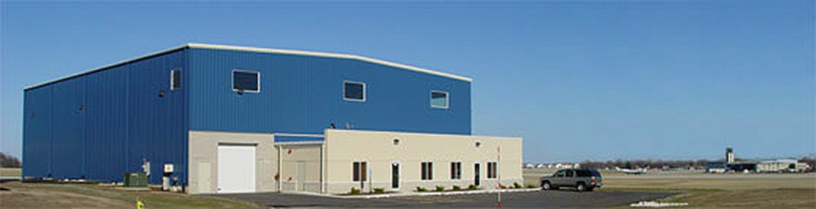
The Warbird Heritage Foundation Headquarters and Hangar is located at the Waukegan National Airport in Waukegan, Illinois, about 50 miles North of Downtown Chicago.
Our Hangar is on the Northwest corner of the airport, just North of the arrival end of Runway 5.
IMPORTANT NOTICE:
Viewing of our aircraft is by appointment only. Please DO NOT drive up to the gate without making arrangements in advance.
DRIVING DIRECTIONS
From Southern Wisconsin:
- Approach the Illinois State Line Southbound on I-94.
- Exit to Hwy 41 South at the Illinois State Line.
- Continue South on Hwy 41 approximately 1 mile to Rosecrans Road (Hwy 173).
- Go East on Rosecrans Road (Hwy 173) just over 3 miles to Green Bay Road (Hwy 131).
- Go South on Green Bay Road (Hwy 131) just over 3 miles to Beach Road.
- Turn East on Beach Road and continue to the end and through the airport security gate to the WHF HQ / Hangar.
- Beach Road is a small residential street in Waukegan located slightly North of the midpoint between Yorkhouse Road on the South, and Wadsworth Road on the North.
- Click on the 'Our Location' button above and check the aerial map for the location of Beach Road relative to the airport, and for the exact location of the Warbird Heritage Foundation HQ / Hangar.
- Click on the 'Highway Map' button above for an overview of the highways in the airport area.
From the Northern Suburbs:
- Take Edens Expresway (I-94) North until it ends and continues on as Hwy 41.
- Continue North on Hwy 41 to Belvidere Road (Hwy 120). Hwy 120 is approximately 14 miles North of the Clavey Road exit on Edens.
- Take Hwy 120 East less than 1 mile to Green Bay Road (Hwy 131).
- Go North on Green Bay Road (Hwy 131) for approximately 7 miles to Beach Road.
- Turn East on Beach Road and continue to the end and through the airport security gate to the WHF HQ / Hangar.
- Beach Road is a small residential street in Waukegan located slightly North of the midpoint between Yorkhouse Road on the South, and Wadsworth Road on the North.
- Click on the 'Our Location' button above and check the aerial map for the location of Beach Road relative to the airport, and for the exact location of the Warbird Heritage Foundation HQ / Hangar.
- Click on the 'Highway Map' button above for an overview of the highways in the airport area.
From the Northwest, Western, and Southern Suburbs, and the O'Hare Airport area:
- Go North on Tri-State Tollway (I-294) past O'Hare Airport.
- Continue past the point where I-294 merges back into I-94 (approximately 12 miles North of O'Hare).
- Continue North on I-94 to Belvidere Road (Hwy 120). Hwy 120 is approximately 24 miles North of O'Hare.
- Take Hwy 120 East approximately 2.5 miles to Green Bay Road (Hwy 131).
- Go North on Green Bay Road (Hwy 131) for approximately 7 miles to Beach Road.
- Turn East on Beach Road and continue to the end and through the airport security gate to the WHF HQ / Hangar.
- Beach Road is a small residential street in Waukegan located slightly North of the midpoint between Yorkhouse Road on the South, and Wadsworth Road on the North.
- Click on the 'Our Location' button above and check the aerial map for the location of Beach Road relative to the airport, and for the exact location of the Warbird Heritage Foundation HQ / Hangar.
- Click on the 'Highway Map' button above for an overview of the highways in the airport area.
From Downtown Chicago:
- Take the Kennedy Expressway (I-90 & I-94) North from Downtown Chicago to the Kennedy-Edens junction (approximately 7-8 miles).
- Take the Edens Expresway (I-94) North until it ends and continues on as Hwy 41.
- Continue North on Hwy 41 to Belvidere Road (Hwy 120). Hwy 120 is approximately 30 miles North of the Kennedy-Edens junction.
- Take Hwy 120 East less than 1 mile to Green Bay Road (Hwy 131).
- Go North on Green Bay Road (Hwy 131) for approximately 7 miles to Beach Road.
- Turn East on Beach Road and continue to the end and through the airport security gate to the WHF HQ / Hangar.
- Beach Road is a small residential street in Waukegan located slightly North of the midpoint between Yorkhouse Road on the South, and Wadsworth Road on the North.
- Click on the 'Our Location' button above and check the aerial map for the location of Beach Road relative to the airport, and for the exact location of the Warbird Heritage Foundation HQ / Hangar.
- Click on the 'Highway Map' button above for an overview of the highways in the airport area.
AERIAL VIEW
Click on the image for a larger view.

HIGHWAY MAP
Click on the image for a larger view.
